environment
Heat Waves Are Becoming a Fire Warning Signal
New 2026 research from UC Merced finds that heat waves and the five days after them accounted for about 42% of western U.S. burned area from 2001–2024 despite representing only 12–15% of warm-season days. The emerging evidence shows how atmospheric moisture demand, nighttime humidity, fuel drying and lightning can make heat waves a distinct wildfire-risk signal.





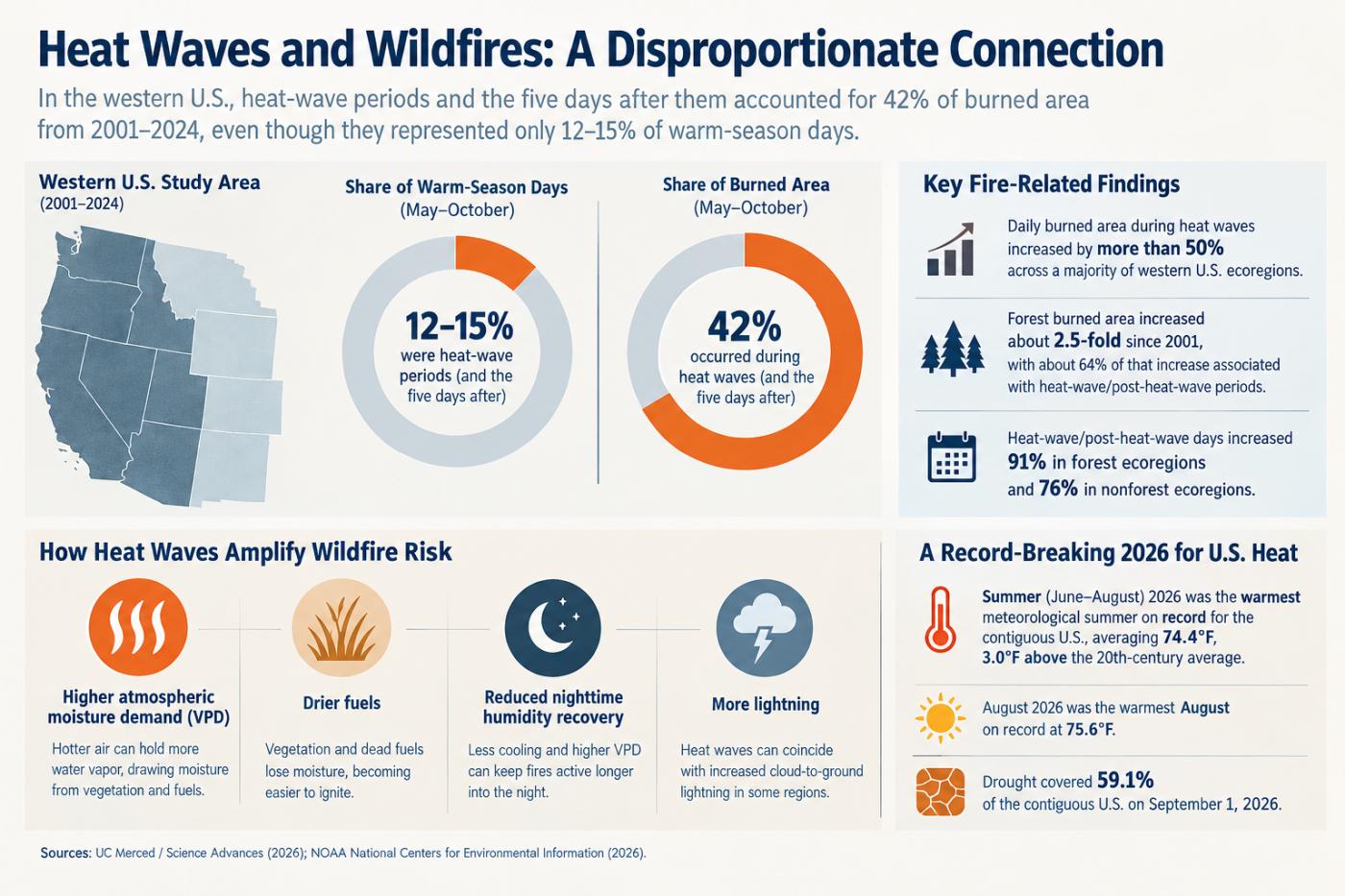
Heat Waves Are Becoming a Wildfire Signal, Not Just a Temperature Event
For most Americans, a heat wave and a wildfire remain two different hazards. One appears in a temperature forecast and triggers heat advisories; the other appears in fire-weather forecasts, evacuation warnings and smoke maps. But new research from the University of California, Merced suggests that this separation is increasingly difficult to justify in the western United States.
A study published in Science Advances in June 2026 found that about 42% of the area burned by wildfire across the western United States between 2001 and 2024 occurred either during a heat wave or in the five days immediately afterward. Those heat-wave periods represented only about 12% to 15% of warm-season days. The research was conducted by Dmitri A. Kalashnikov, John T. Abatzoglou, Emily L. Williams, Cong Yin, Madhulika Gurazada, Mukesh Kumar, Ashwin P. Thomas and Precious E. Ebiendele. The researchers analyzed satellite-derived burned area, fire-occurrence records and gridded meteorological data across western U.S. ecoregions.
The finding is important because it changes the way the timing of wildfire risk should be understood. A heat wave does not merely coincide with a landscape that happens to be dry. It can actively alter the landscape's flammability, suppress nighttime recovery of humidity, increase atmospheric demand for moisture, prolong periods of active fire and, under some circumstances, increase lightning ignitions.
As Kalashnikov and his colleagues put it, “heatwaves both catalyze and enable warm-season wildfire activity across the WUS.”
That distinction has practical implications. If heat waves are treated only as a public-health hazard, fire managers and communities may miss an important early signal that the landscape itself is entering a different fire regime.
The 2026 Climate Background Is Already Extreme
The timing of the new research is particularly striking because the United States has just experienced an extraordinary summer. NOAA's National Centers for Environmental Information reported that meteorological summer June through August 2026 was the warmest on record for the contiguous United States in the 132-year instrumental record. The average exceeded the previous records from 1936 and 2021 by 0.4°F. August itself was also the warmest August on record, while the average daytime maximum temperature for the month reached a record 88.6°F.
The broader drought picture adds another layer. The U.S. Drought Monitor reported in September that the record-hot summer was accompanied by below-normal precipitation and widespread drought, with nearly half of the country experiencing drought conditions. The combination helped produce a destructive 2026 wildfire season and extensive smoke impacts.
Temperature records by themselves do not explain wildfire behavior. Fire requires fuel, an ignition source and conditions that allow the fire to spread. But the 2026 evidence suggests that extreme heat can modify several of those ingredients at once.
This is why the heat-wave finding is more consequential than simply saying that hot weather is associated with fire. The relationship is nonlinear: a relatively small portion of the calendar is associated with a disproportionately large share of burned area.
The Atmosphere Can Become Thirstier Even Before Plants Look Dead
One of the most important mechanisms is vapor pressure deficit, or VPD. Rather than measuring temperature or relative humidity separately, VPD describes the atmosphere's capacity to draw moisture from surfaces and vegetation. A hotter atmosphere can hold more water vapor, so the same relative humidity at a higher temperature can correspond to a much stronger drying demand.
This matters because vegetation can lose moisture to the atmosphere rapidly during periods of high VPD. Leaves, grasses, needles and other fine fuels can become easier to ignite, while larger dead fuels gradually lose moisture as the heat persists.
Research by Andrew M. Chiodi of NOAA and Brian E. Potter of the USDA Forest Service found that nighttime vapor pressure deficit increased substantially across portions of the western United States between 1980 and 2019. In some foothill regions adjacent to arid plateaus, nighttime VPD increased by more than 50% over the 40-year period. The authors examined the change because fire managers had reported that fires were remaining active later into the night than earlier in their careers.
The significance of nighttime conditions is easy to underestimate. Historically, the overnight period has often provided a natural brake on wildfire behavior. Temperatures fall, humidity rises and fine fuels can partially recover moisture. Firefighters may then gain a tactical advantage before daytime heating begins again.
When overnight atmospheric dryness remains elevated, that recovery becomes weaker. A fire does not necessarily reset every morning. Instead, it can carry momentum from one day into the next.
The Chiodi and Potter research does not establish that every nighttime VPD increase is caused by heat waves, nor does it claim that nighttime conditions alone determine fire behavior. Its importance is that it demonstrates a changing background environment in which the distinction between daytime and nighttime fire weather is becoming less pronounced in some parts of the West.
The Five Days After the Heat Wave Matter
Perhaps the most overlooked finding of the 2026 UC Merced study is temporal rather than geographical. The researchers did not stop their analysis when the temperature returned below the heat-wave threshold. They examined the five days immediately following heat waves as well.
That five-day extension is critical because fuels do not necessarily respond instantaneously to temperature. A prolonged heat event can progressively remove moisture from vegetation and dead organic material. When the heat wave ends, the thermometer may return toward normal while the fuel remains unusually dry.
This creates what might be called a fire-weather memory: the atmosphere returns to more ordinary conditions faster than the landscape does.
The study found that daily burned area during heat waves increased by more than 50% across a majority of western U.S. ecoregions relative to pre-heat-wave conditions. It also found that the effects persisted after the heat event in most regions.
This is one reason the conventional idea of a heat wave as a discrete three-day or five-day weather event can be misleading for fire management. From a human-health perspective, the heat warning may end when temperatures fall. From a wildfire perspective, the most dangerous period may not end simultaneously.
Heat Does Not Affect Every Landscape in the Same Way
The relationship becomes even more interesting when the western United States is divided by ecosystem.
The UC Merced researchers found that forested regions behaved differently from nonforested regions. Forest burned area increased 2.5-fold between 2001 and 2024, and approximately 64% of that increase coincided with heat-wave periods. The researchers did not find an equivalent increase in nonforested areas.
This distinction matters because wildfire is not controlled by weather alone. Some ecosystems are flammability-limited: there is plenty of combustible vegetation, but whether it becomes highly flammable depends strongly on atmospheric and fuel conditions. Other ecosystems are more fuel-limited: even very hot conditions cannot produce a huge fire if insufficient vegetation is available to burn.
The Great Basin provides a useful example. Grasslands and shrublands can experience different relationships between precipitation, vegetation growth and fire. A wet year may produce abundant fine fuels that subsequently become available for burning. Consequently, a heat wave in a fuel-rich year can have a different effect from an equally intense heat wave following a season with limited vegetation growth.
This helps explain why a national or regional temperature forecast cannot simply be translated into a uniform wildfire-risk multiplier. The same heat event can increase risk dramatically in one ecosystem while having a much smaller effect somewhere else.
Heat Waves Can Increase the Number of Ignitions, Not Just Fire Spread
Another important mechanism is ignition.
A wildfire needs something to start it. Human activities such as equipment use, campfires, vehicles and power infrastructure remain important ignition sources. But heat waves can also occur in atmospheric situations conducive to lightning.
The UC Merced researchers found that heat waves co-occurred with increased cloud-to-ground lightning. That does not mean every heat wave generates lightning or that lightning was responsible for the majority of fires during the study period. It does mean that extreme heat can sometimes coincide with an increase in one of the most important natural ignition mechanisms.
This produces an unusual compound effect. Heat can make the fuel easier to ignite while the same atmospheric setup may increase the number of opportunities for ignition. Once a fire begins, the already-dried landscape can support faster growth.
Human ignitions can also become more consequential. UC Merced researchers reported increased human-caused wildfire activity during heat waves in parts of the Northwest, where unusually dry conditions can make an otherwise minor accidental ignition more likely to develop into a significant fire.
Why Wind-Centered Fire Warnings May Miss Part of the Story
Wildfire forecasting already incorporates many of the variables that matter: temperature, relative humidity, wind, precipitation and fuel moisture. Modern fire-danger systems are therefore not blind to heat.
The issue identified by the new research is more subtle. A heat wave is a multi-day process, while many operational fire-weather warnings are designed around immediate or near-term conditions.
The UC Merced paper explicitly notes that heat waves are not directly codified into operational fire-weather warnings such as Red Flag Warnings, which generally emphasize combinations of wind and humidity thresholds.
This does not mean Red Flag Warnings are obsolete or inadequate for their intended purpose. Rather, they answer a somewhat different question: are immediate weather conditions favorable for rapid or extreme fire behavior?
A heat-wave indicator could answer another question: has the landscape recently experienced an unusually prolonged atmospheric drying event that has increased its susceptibility to fire?
Those two signals could be complementary.
A location might not meet the traditional combination of wind and humidity thresholds at 2 p.m. on a particular day, yet still contain fuels that have undergone several days of extreme atmospheric drying. Conversely, a short-lived heat event accompanied by high humidity and rainfall may have a much smaller effect on forest fire activity.
The Difference Between Hot and Dry Heat Is Critical
Not every heat wave should be treated as an extreme wildfire signal.
The UC Merced study distinguished between dry and moist heat waves. Dry heat waves were much more strongly associated with increased forest fire activity, because they combine high temperatures with low humidity and therefore greater atmospheric demand for moisture.
This is an important qualification because it prevents the research from becoming a simplistic argument that every heat advisory should automatically become a wildfire warning.
A humid heat wave can be extremely dangerous for people while producing a very different fire response from a dry heat wave. In some circumstances, rainfall associated with moist conditions can even temporarily reduce fuel flammability.
The distinction reinforces the importance of VPD. Temperature alone does not tell us how aggressively the atmosphere is extracting moisture from vegetation. Two places with identical temperatures can have very different wildfire environments if their humidity differs substantially.
Wildfire Geography May Change Before the Public Notices
The interaction between heat and fire also has implications for geography.
Long-term wildfire projections have traditionally focused on regions that are already recognized as fire-prone. But research summarized by the U.S. Geological Survey shows that projected changes in temperature and climate conditions can alter wildfire probability across the continental United States, including regions not historically associated with frequent wildfire. A 2021 USGS-linked study projected increases in potential fire probability in areas such as New England and the Great Lakes under higher-emissions scenarios.
The newer heat-wave evidence adds another dimension. The geography of wildfire risk does not only depend on whether a place becomes warmer on average. It can depend on whether extreme heat increasingly arrives at the same time as adequate fuel, low humidity, ignition sources and favorable fire-weather conditions.
That means the future map of wildfire risk may be shaped partly by changes in the frequency and timing of compound conditions, rather than by annual average temperature alone.
This is particularly important for communities near the margins of established fire regimes. A place does not need to become California to experience a new level of wildfire risk. A modest change in the frequency of the right combination of heat, dryness and fuel can change the probability of extreme events.
There Is Also a Public-Health Feedback Loop
The interaction does not stop with the landscape.
Heat waves already increase demand for electricity, place stress on transportation infrastructure and increase heat-related illness. Wildfires add smoke exposure, evacuation, respiratory stress and disruption to medical services.
When the two occur together, the risks can compound rather than simply add.
Air-conditioning demand can be high precisely when wildfire smoke is reducing outdoor-air quality. People may remain indoors because of heat while simultaneously needing to manage indoor smoke exposure. Emergency services can face increased demand from heat illness at the same time that fire threatens communities and transportation routes.
Emily L. Williams, one of the UC Merced researchers, captured this interaction by saying: “Climate impacts aren't neatly siloed. They are messy, they interact and exacerbate each other.”
This is more than a communications issue. Emergency planning is frequently organized around individual hazards because agencies have specialized responsibilities. Heat emergencies may involve public-health departments and weather services, while wildfires involve fire agencies, emergency managers and land-management organizations.
A compound event can cross those administrative boundaries even when the underlying physical processes are closely connected.
The Warning Window Could Be Longer Than a Red Flag Day
The most practical implication of the new research may therefore be a change in the timing of preparedness.
If heat waves increase wildfire risk and leave a residual effect for several days, then fire agencies could potentially use the onset of a forecast heat wave as an early signal for resource planning rather than waiting until traditional fire-weather thresholds are reached.
That could mean increased monitoring of remote areas, checking communications systems, reviewing evacuation routes, positioning suppression resources or increasing public messaging about ignition prevention before a fire starts.
The objective would not necessarily be to issue another warning to the public every time temperatures rise. Instead, heat-wave information could become one input into a broader risk assessment that already considers fuel moisture, drought, wind, lightning and recent fire history.
The research supports such an approach without establishing a universal operational threshold. The authors themselves state that their results can improve predictions of wildfire risk, but the study does not prescribe a particular warning system or claim that heat waves independently determine fire outcomes.
Wildfire Models Are Getting Better but the Compound Problem Is Harder
Modern wildfire models already incorporate substantial physical information. USGS quantitative wildfire risk assessments, for example, integrate fuels, topography, weather and values at risk. The agency's 2026 review of wildfire susceptibility assessments found considerable variation in how response functions and values are represented across assessments, highlighting the complexity of translating physical fire behavior into risk estimates.
Other USGS work has shown that simulation-based burn-probability maps can be useful but are not perfect predictors of where the largest fires will occur. In a 2025 evaluation covering 128 fire-regime regions, the mean burn probability was moderately correlated with observed burned area, but the models underpredicted burned area in the Mountain West, particularly for extremely large fires.
The lesson is not that wildfire models are failing. It is that wildfire risk is inherently a moving target. Fuel conditions change, ignition patterns change, atmospheric conditions change and human development changes the consequences of a fire.
Heat waves add another layer because they operate simultaneously on several parts of that system. They can change fuel moisture, atmospheric dryness, nighttime recovery, fire duration and potentially ignition frequency. A model that considers each variable individually may capture much of the physics, but the timing and interaction among variables can still create nonlinear outcomes.
The Five-Day Echo May Be More Important Than the Heat-Wave Peak
There is a broader conceptual implication here. Climate risk is often communicated using the peak of an event: the hottest day, the strongest wind or the lowest humidity.
Wildfire risk may increasingly depend on the accumulated history of weather.
Five consecutive days of extreme heat can affect fuels differently from one extremely hot afternoon. A sequence of hot nights can prevent recovery even when daytime temperatures fluctuate. A heat wave followed by a windy period can create conditions that were not obvious when the heat itself was occurring.
This means the most informative fire-risk question may sometimes be less “How hot is it today?” and more “What has the atmosphere done to the landscape during the past week?”
That shift from instantaneous conditions to environmental memory is one of the most useful insights emerging from the 2026 research.
The Geography of Fire Risk Is Becoming More Dynamic
The western United States remains the clearest focus of the evidence, and the new study should not be interpreted as proof that heat waves will produce the same wildfire response everywhere in the country.
But the underlying mechanism is broadly relevant. A warmer atmosphere increases evaporative demand. More frequent or intense heat can create more episodes in which vegetation and dead fuels lose moisture rapidly. Changes in nighttime humidity can reduce recovery. Changes in atmospheric circulation can influence lightning and wind. And changes in vegetation can determine whether enough fuel exists to translate those conditions into a large fire.
The result is a wildfire geography that can change not only because forests become drier, but because the timing of extreme weather increasingly overlaps with the periods when fuels are capable of carrying fire.
For communities, that makes heat-wave forecasts potentially useful for more than protecting people from heat illness. They may also provide an early indication that the surrounding landscape is entering a period in which wildfire risk is unusually elevated even if a traditional fire-weather warning has not yet been issued.
The 2026 UC Merced study does not suggest abandoning established fire-danger systems. Its more consequential message is that the systems could potentially become more informative if heat waves were treated as a distinct component of wildfire risk. With heat waves already occupying a small fraction of the warm season while accounting for a disproportionately large share of burned area, the gap between weather forecasting and wildfire preparedness may increasingly be found not in what either system measures, but in how their signals are connected.